

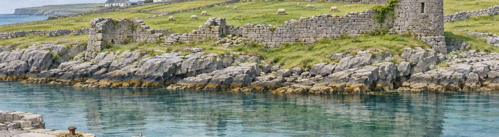
From the quay at Cill Éinne, on the south-east coast of Inis Mór, look west to spot the remains of Arkin Castle. In places, the masonry blends into the shoreline. Yet this wall once overlooked the island’s main harbour. Its Irish name, Caisleán Aircín, preserves the memory of this small natural shelter, where successive powers sought to control arrivals by sea.
To understand why this site was chosen, picture Inis Mór before Kilronan became the island’s main arrival point. Until the 19th century, Cill Éinne harbour held a central role. Its inlet provided shelter for boats. The castle’s position, close to the water, made it possible to watch movements at the harbour entrance while retaining direct access to the shore.
Heritage Ireland dates an early O’Brien fortification here to the 13th century. In the 16th century, control of the site passed to the Uí Fhlaithbheartaigh, the O’Flahertys of Connemara. The English Crown later reclaimed the site, making it a royal estate under Elizabeth I in 1587. The names Arkin and Arkyn refer to the same place. The remains visible from the quay belong chiefly to a later phase in its history.
In the mid-17th century, after Galway was taken by the forces of the English Commonwealth, Cill Éinne became a military post tasked with watching access to Galway Bay. A new enclosure replaced the castle. According to the Office of Public Works, around 100 soldiers were stationed here. Their presence gives an indication of the harbour’s strategic importance at a time when connections with the mainland depended on control of anchorages.
Local tradition holds that stones from the round tower and nearby churches were reused in the fortification. The fort also briefly served as a prison for Catholic priests in the 1650s. After 1700, it was occupied only intermittently. Through these changes, the same site evolved from defending an island harbour to providing military surveillance of an entire bay.
A late-18th-century drawing shows an enclosure flanked by four towers, two square and two circular. Only one remains. Part of the northern wall is still standing. At the western end of the curtain wall, an opening once provided access to the fort from the sea. It is one of the site’s most revealing details. In a fortified place so close to the water, access by boat was part of its layout.
From the quay, begin by picking out the line of the wall before looking for the features that stand out from it. Stepping back helps distinguish the fortification from the rock and other stone walls. In low-angle light, differences in the masonry’s relief are easier to make out. Binoculars will help you spot the opening without approaching the remains.
The Office of Public Works states that the monument can be viewed from outside and recommends looking west from the quay. The view places the fort back in its original setting, with the inlet in the foreground. This is an observation stop in a harbour where boats may still be in operation.
To extend your outing from Kilronan, pair the old harbour with Teampall Bheanáin, the small stone church on the heights, or the religious remains of Killeany Abbey. These stops bring together two aspects of Cill Éinne’s history: its religious communities and its fortified harbour. They offer a route through the east of the island, away from the way to Dún Aonghasa.
Essential information to help you plan your visit, including key landmarks, access information, and booking options.
Cill Éinne Pier, Inishmore, Aran Islands, County Galway, Republic of Ireland, Tourist sites in Ireland
53.104899, -9.662298
External viewing only. No visiting hours have been published.
Check the opening hours and admission requirements before you leave, especially during peak season or on Irish public holidays.
No admission charge for viewing from the quay.