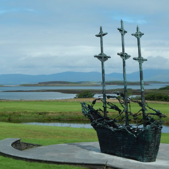


On the coast of County Mayo, Clew Bay reveals an extraordinary landscape: a bay dotted with a multitude of low-lying islands, water-bound pastures and sea channels, with Croagh Patrick on the horizon. Tradition holds that it has 365 islands, one for every day of the year. It is an appealing idea, best regarded as local lore rather than an indisputable geographical count.
There are several complementary ways to discover the bay: drive along its shores, cycle part of the greenway, walk by the coast or take a boat to Clare Island. The aim is not to see everything in one day, but to choose a few stops that allow you to appreciate this ever-changing landscape between land and Atlantic Ocean.
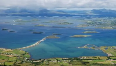
Clew Bay — © Anna Efremova
Clew Bay’s distinctive character is easier to understand once you know how its islands were formed. Many are drumlins, hills of glacial deposits shaped by the ice. After the glaciers retreated and sea levels rose, their highest sections remained visible above the water.
These landforms give the inner bay its rounded contours and remarkable patchwork of land and channels. This is not, therefore, an archipelago made up solely of steep rocks: some islands are covered in pasture, while others are little more than small outcrops.
The tides also transform the appearance of the landscape. At low tide, mudflats and exposed ground emerge; at high tide, the water brings the outlines of the islands into sharper relief. Returning to the same spot a few hours later can therefore reveal a very different view.
The figure of 365 is part of Clew Bay’s identity, but the total depends in particular on what is considered an island, an islet or a feature exposed by the tide. It is best to enjoy the image — one island for every day of the year — without treating it as a scientific claim.
To understand the layout of the bay, alternate between different viewpoints. From the shore, the islands can overlap and appear to form a continuous strip of land. From slightly higher ground, the waterways become easier to distinguish, revealing the full complexity of the landscape.
Westport makes a convenient base for exploring Clew Bay. A walk around Westport Quay offers an immediate introduction to its maritime setting before you continue north.
The N59 links Westport, Newport and Mulranny, among other places. It provides a useful route through the area, but does not follow the water’s edge throughout: at times, you will need to take a minor road or stop for a walk to enjoy the coastline. Plan a few stops rather than expecting uninterrupted views from the car.
Newport is a good place to pause, while the area around Mulranny offers another perspective on the bay. Drive slowly on minor roads and park only in designated spaces. Property entrances and passing places are not makeshift car parks.
To explore the southern shore, take the R335 from Westport towards Murrisk and Louisburgh. This route brings you to the foot of Croagh Patrick and offers opportunities to discover the coast without setting out on a mountain hike.
You can spend half a day making a few stops along this shore, or extend the outing towards the area around Louisburgh. A manageable itinerary might combine a viewpoint, a short walk and a break in a village, while allowing some flexibility for changes in the weather.
The bay is not simply a succession of broad sandy beaches. Its shores encompass a variety of environments: rocky stretches, beaches, coastal marshes and areas exposed by the tide. This diversity is precisely what makes exploring it so rewarding.
The Great Western Greenway, which links Westport and Achill, offers a way to explore part of the region by bike or on foot. It does not follow the shoreline throughout, but passes through landscapes that complement a visit to the bay.
There is no need to cover the entire route to enjoy it. Choose a section suited to your ability and arrange your return before setting off: travel out and back, use a transfer offered by a bike-hire company or confirm another option. You should also check the hire conditions and what equipment is provided.
When walking, stick to marked routes and public access points along the coast. An expanse of ground exposed at low tide is not an invitation to cross to an island: channels, mud and the incoming tide can make such crossings dangerous.
From the upper slopes of Croagh Patrick, the islands of Clew Bay take on a new dimension. The view encompasses their rounded forms, the channels and the opening towards the Atlantic. When visibility allows, this is one of the mountain’s great attractions.
The ascent is nevertheless a demanding hike and requires suitable footwear, clothing for wind and rain, and favourable weather. Do not treat it as a casual stroll undertaken simply to take a photograph. If the summits are shrouded in cloud, exploring the coast will often be more rewarding.
From the water, the islands no longer merge into one another and their individual outlines become clear. A guided trip allows you to explore the bay while benefiting from the knowledge of a crew accustomed to local conditions.
Before booking, check the departure point, duration, route and whether the trip includes a stop. A sightseeing cruise does not necessarily include landing on an island. Services and departure times depend on the operator, the season and sea conditions.
Hiring a boat without a crew involves more than simply holding a licence: requirements vary according to the provider and the vessel. For a first visit, a guided excursion is a simpler option to arrange.
At the entrance to Clew Bay, Clare Island stands out for its higher ground and coastal scenery. It is also associated with Grace O’Malley, a major figure in Ireland’s maritime history. The island deserves a dedicated outing rather than a detour added at the last minute.
Regular crossings depart from Roonagh Pier, near Louisburgh. Check the Clare Island Ferry Company timetable or that of your chosen operator, then confirm your return sailing. Weather conditions may affect departures.
On the island, adapt your walk to the time available between sailings. Exploring the area around the harbour and hiking over higher ground require very different levels of commitment. Bring water, a jacket and something to eat, particularly outside the main season, when food options may be more limited.
Half a day is enough to explore one shore and a few viewpoints. Allow more time if you want to combine several areas, a bike ride or a crossing to Clare Island. A car makes exploring easier, but rushing from one stop to the next would mean missing the essence of the experience: walking for a while, watching the tides and seeing the light change across the islands.
Bring suitable footwear, waterproof clothing and, if you enjoy birdwatching, binoculars. Keep your distance from wildlife and respect fences and farmland. For boat trips and hikes, check conditions on the day: on this coast, the weather is very much part of the journey.
Want to extend your visit without having to rush around? Here are a few well-located places to stay near the must-see attractions.
Essential information to help you plan your visit, including key landmarks, access information, and booking options.
pour suivre la Clew Bay par la route, prendre la N59, County Mayo, Republic of Ireland, Tourist sites in Ireland
53.834313, -9.799657