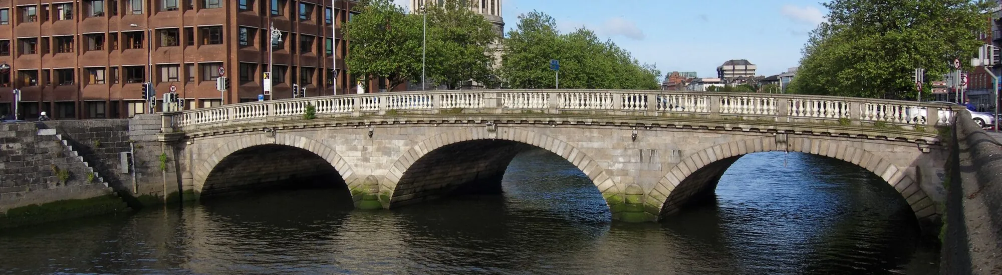
Near the Four Courts, three granite arches carry Church Street over the Liffey. Cars pass across, pedestrians make their way from one quay to the other, and most have already crossed the Father Mathew Bridge before its form comes into view. To see it, you need to walk down along the quay and turn around. The bridge dates from the early 19th century. Its location, however, tells a much longer story. It was in this area that Dublin’s earliest bridges linked the medieval city to the north bank.
Before the quays formed the continuous lines we follow today, crossing the Liffey meant choosing your way across. The National Inventory of Architectural Heritage’s survey of north Dublin places the ford associated with Áth Cliath, the Irish name for the city, a little west of the present bridge. An initial wooden bridge linked the fortified city on the south bank with Oxmantown to the north. The inventory dates its replacement by a stone bridge to around the beginning of the 13th century. To picture this route, start on Bridge Street Lower and look along Church Street, which continues the line of the roadway. These two street names suggest the continuity of the crossing, despite the successive changes to the riverbanks.
According to the Dublin urban archaeology report, the medieval bridge held shops, homes and a chapel. On the south side stood a structure controlling access to the crossing. Imagine a built-up street above the river, where people could stop to shop or enter a building. The same report states that work on the present bridge uncovered older foundations in 1816. The succession of structures is therefore documented underground, even if, from the pavement, it is the 19th-century granite that lies before you.
The present bridge was designed by George Knowles and built between 1816 and 1818. Its original name, Whitworth Bridge, honoured Charles Whitworth, Lord Lieutenant of Ireland. Seen from the side, its deck forms a gentle hump. The three elliptical arches and the dressed stone blocks edging them are its most easily read features in the landscape. At the base of the piers, cutwaters project into the riverbed, diverting the water around the supports. The bridge’s architectural inventory also notes its cast-iron balusters. From the pavement, these elements give the structure a different scale, having first been seen from the quays as a single expanse of stone.
In 1938, the bridge was named after Father Theobald Mathew. This Irish Capuchin, born in 1790 and died in 1856, became known in the 19th century for his temperance campaign. In Cork, from 1838, he encouraged participants to take a pledge of abstinence. The movement later spread beyond the city and drew large crowds. His entry in the Dictionary of Irish Biography traces this story. The bridge’s name thus belongs to Ireland’s social history, while its construction date still recalls the period when Dublin was administered under British authority.
To photograph the stonework and arches, move onto one of the quays before crossing. On the south side, stand west of the bridge and look downstream. The façade of the Four Courts, on the opposite bank, provides a second focal point in the composition. A view taken almost in line with the roadway shows the shape of the deck more clearly, though the piers disappear from view. Allow around ten minutes to compare the two perspectives. The bridge remains a road route and the junctions are busy. Pavements and designated crossings allow you to observe the details while keeping clear of traffic lanes.
From Smithfield, make your way along Church Street and down towards the Liffey. Once on the other side, Bridge Street Lower leads towards the streets of old Dublin and The Liberties. For a walk focused on bridges, follow the river eastwards instead as far as the Ha’Penny Bridge. It is almost contemporary with Father Mathew Bridge, but its cast-iron arch and pedestrian use offer a different way of crossing the river. Just a few quays apart, the two structures show two early 19th-century responses to the same question of urban planning.
Want to extend your visit without having to rush around? Here are a few well-located places to stay near the must-see attractions.
Essential information to help you plan your visit, including key landmarks, access information, and booking options.
Church Street / Bridge Street Lower, Smithfield, Dublin, County Dublin, Republic of Ireland, Tourist sites in Ireland ; The Liberties, Dublin, County Dublin, Republic of Ireland, Tourist sites in Ireland
53.3455, -6.2757
Public road bridge accessible on foot at all times, subject to temporary traffic restrictions.
Check the opening hours and admission requirements before you leave, especially during peak season or on Irish public holidays.
Free pedestrian access via the bridge pavements.