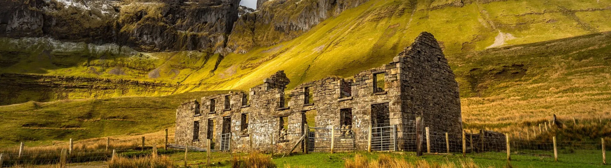
In the north of County Sligo, the Gleniff Horseshoe runs through one of the most spectacular valleys in north-west Ireland. This scenic loop winds between the limestone cliffs of the Dartry Mountains, in a landscape shaped by glaciers, rivers and waterfalls.
The route can be explored by car, bike or on foot. Whichever option you choose, the setting remains the same: a narrow road winding along the floor of a horseshoe-shaped valley, beneath the imposing outlines of Benwiskin and Truskmore. On clear days, some stretches also offer fine views towards Donegal Bay.
The Gleniff Horseshoe lies near Ballintrillick, just over 25 kilometres from the town of Sligo. It can also be reached from Cliffoney, Mullaghmore or Bundoran.
The road loop is approximately 10 kilometres long. It follows a narrow, single-track tarmac road through pastureland, alongside watercourses and beneath almost vertical cliffs. The route is relatively easy to follow, but it is not a tourist road closed to traffic: cars, cyclists, walkers and farm vehicles may all meet along the way.
The site remains quieter than Ireland’s major coastal attractions, but it is no longer truly unknown. Visitor numbers rise on sunny weekends and during the high season. It is therefore essential to respect local residents, working farms and private property.
Without stops, the loop can be driven in 25 to 30 minutes. It is nevertheless best to allow 45 minutes to an hour to enjoy the scenery and stop only in places wide enough to do so.
Many visitors prefer to drive the circuit clockwise, particularly to see the mountain amphitheatre gradually unfold. The road is open in both directions, however. You should therefore expect to encounter oncoming vehicles, including on the narrowest stretches.
The verges can be soft or lined with ditches. Avoid parking in front of farm entrances, on private land or in passing places. Owing to the road’s limited width, motorhomes and large vehicles may encounter difficulties. Any local signage should always be followed.
The route also passes close to Magic Hill, a curiosity where the slope of the landscape creates the impression that a vehicle is moving uphill. It is an optical illusion caused by the lack of a clearly visible horizon. Do not attempt any vehicle experiment when there is traffic or when conditions are not safe.
The official walk associated with the Gleniff Horseshoe is known as the Benwiskin Trail. Its starting point is near the Benwiskin Centre, where there is an information board and some parking available.
The route is 13.5 kilometres long and has a modest elevation gain of around 40 metres. This limited change in altitude should not, however, obscure the length of the walk. Sligo Walks rates it as moderate and gives a walking time of around 2 hours 30 minutes. To walk at a relaxed pace, take photographs and stop a few times, it is better to allow between 3 and 4 hours.
The route mainly follows country roads and a few woodland sections. It is not continuously waymarked. A map downloaded in advance or an offline walking app may therefore be useful. On stretches without pavements, stay alert to traffic and make yourself visible, especially as the light fades.
Sturdy walking shoes are preferable to ordinary trainers. Rain can make some sections muddy or slippery, while wind quickly funnels through the valley. Bring water, a waterproof layer and enough food for the time you plan to be out.
Visitors who do not wish to complete the larger loop can stop at the Gleniff Barytes Mill Site. A woodland trail of around 1.5 kilometres follows the river to an old dam, offering views of small waterfalls, channels and various industrial remains.
This walk is much shorter than the Benwiskin Trail and makes a good option for a break or picnic. Benches have been installed on the site. The ground can nevertheless become wet and uneven after rain.
The Gleniff Horseshoe occupies a glacial valley carved into the Dartry Mountains. Ancient ice masses gradually eroded the rock and shaped this deep valley with its steep sides.
The limestone layers are particularly visible in the cliffs. They form long horizontal strata, broken by ravines and gullies where water runs after rainfall. Waterfalls are therefore more numerous and more powerful after a wet spell, although clouds may then obscure the mountain tops.
Benwiskin dominates part of the loop with its strikingly regular profile. Truskmore, the highest point in the Dartry Mountains, closes off another part of the horizon. Further south-west, the distinctive outline of Ben Bulben is a reminder that the whole area belongs to the same mountain range.
Looking up towards the cliffs, you can make out a dark opening known as Diarmuid and Gráinne’s Cave. According to Irish tradition, the two lovers took refuge there while fleeing the warrior Fionn mac Cumhaill, to whom Gráinne had been promised.
The cave sits high in the cliff face and strongly contributes to the atmosphere of the Gleniff Horseshoe. It should, however, be admired from the valley floor. Access to it is not part of the public walk: the approach crosses private land and extremely steep, unstable and dangerous terrain.
The ascent should not be attempted, even where tracks or old ropes appear to indicate a way through. Emergency services have already had to intervene in this area, and access through land near the former school is not permitted by the owners.
The Gleniff Barytes Mill Site recalls the valley’s industrial past. Baryte, a heavy mineral used in the manufacture of paints, plastics and technical products, was extracted in the surrounding mountains before being processed on site.
Water from the river powered the mill’s facilities through a network of dams, channels and pipes. Part of the production was then transported to Mullaghmore for shipment by boat. The mill ceased operating during the 1920s.
Today, only some foundations and water-management structures remain. The short woodland route allows visitors to discover them without leaving the public part of the site.
Parking is free. The most convenient starting points are at the Gleniff Barytes Mill Site and near the Benwiskin Centre. Spaces are limited: never block a farm entrance or use private yards or tracks as improvised car parks.
The loop has no visitor centre and services are very limited. It is best to use the toilets, buy water and arrange your meal before leaving Cliffoney, Mullaghmore or another nearby village.
The weather can change quickly at the foot of the mountains. A windproof and waterproof jacket are recommended even when the sky appears clear at the outset. In winter, fog, ice and limited daylight can make both driving and walking more difficult.
Dogs must be kept under control and on a lead at all times near livestock. Observe any seasonal restrictions, particularly during the lambing season. Do not climb fences, disturb animals or leave the road to approach cliffs and waterfalls.
The circuit is around 15 minutes from Mullaghmore Head, where a coastal road offers views of the ocean and Classiebawn Castle. Further south, the Benbulben Forest Walk offers another way to explore the Dartry Mountains.
Glencar Waterfall and Glencar Lough are around 30 minutes’ drive away. The Neolithic site of Creevykeel, near Cliffoney, can also be included in a day exploring the north of the county.
Discover Ireland sets out the features of the scenic loop, its activities and its general access conditions. Information on the Benwiskin Trail comes from Sligo Walks. The history of the mill and the short woodland route are documented by Choose Sligo. Restrictions on access to the cave are noted in particular by Caves of Ireland.
Essential information to help you plan your visit, including key landmarks, access information, and booking options.
54.370805, -8.415037