

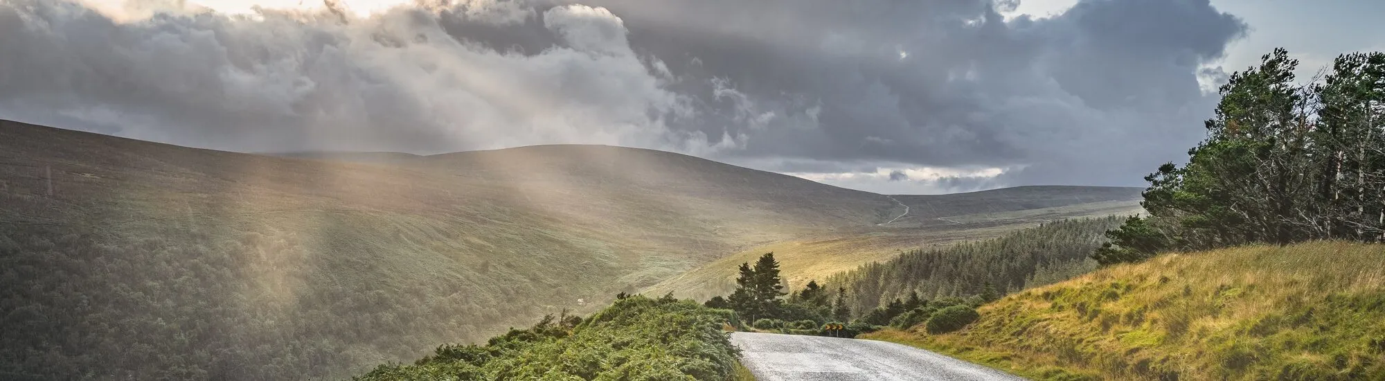
The Old Military Road is one of Ireland’s finest scenic drives. It winds deep into the Wicklow Mountains, crossing vast peat bogs and passing through valleys where all traces of human presence can at times seem to vanish entirely.
Also known as the Great Military Road, this historic route links Rathfarnham, south of Dublin, with Aghavannagh in the southern part of County Wicklow. Much of its route now follows the R115 and passes through Wicklow Mountains National Park.
It offers a striking cross-section of the region’s landscapes: heather-covered moorland, rounded summits, glacial lakes, waterfalls and windswept, empty roads.
The historic Old Military Road route stretches for around 58 kilometres. It begins in Rathfarnham, on Dublin’s southern outskirts, then crosses the uplands of Featherbed, Glencree, Sally Gap, Glenmacnass, Laragh, Glenmalure and Drumgoff before reaching Aghavannagh.
The road can be driven in either direction. However, travelling from north to south is the most natural option for visitors coming from Dublin. Urban scenery gradually gives way to the dark contours of the Wicklow Mountains.
Allow around 1 hour 30 minutes to 2 hours to drive the route without stopping. Half a day is more realistic, however, if you want to enjoy the views, stop a few times and detour to Glendalough. A full day allows time to add a walk or a visit to the monastic site.
A car remains the easiest way to explore the Old Military Road. No regular public transport service covers the entire route. Some private coach tours do cross the national park, however, passing through Sally Gap or Glendalough.
The road’s quiet beauty contrasts with its military origins. The Great Military Road was built between 1801 and 1809, following the Irish Rebellion of 1798.
After the uprising failed, several rebels took refuge in the Wicklow Mountains. Among them was Michael Dwyer, one of the most wanted rebel leaders of his time. The terrain, bogs and lack of passable routes made the area difficult for British forces to access.
The authorities therefore decided to build a road that would allow troops to move quickly through the heart of the mountains. Several military barracks were established along its route, notably at Glencree, Laragh, Glenmalure and Aghavannagh.
The road also had a secondary branch linking Enniskerry and Glencree. Today, military convoys have given way to tourist cars, but its route still reveals the strategic purpose for which it was built.
The most spectacular section of the Old Military Road crosses the high plateau of Wicklow Mountains National Park. The landscape is dominated by blanket bog, a fragile habitat shaped by moisture, altitude and several thousand years of plant accumulation.
Low-growing vegetation opens up wide views of the surrounding summits. Depending on the season, the hills take on brown, green, russet or purple hues when the heather is in bloom.
In clear weather, the light picks out the glacial valleys and contours of the land. When the mist comes down, the mountains take on an entirely different character: the road then seems to disappear into an almost unreal landscape.
Weather conditions can change very quickly. Sometimes, only a few minutes are enough to turn clear skies into heavy rain or near-zero visibility.
At the northern end of the route, the Featherbed uplands mark the transition between Dublin’s outskirts and the wild landscapes of the Wicklow Mountains. The road then skirts the slopes around Kippure, one of the range’s most recognisable peaks thanks to its imposing transmitter.
The Glencree valley is one of the route’s first historic stops. It is home to the Glencree Centre for Peace and Reconciliation and a German military cemetery.
Further south, the road reaches Sally Gap, an isolated crossroads amid the peat bogs. Here, the R115 meets the R759, which leads to Roundwood in one direction and Blessington in the other. This open landscape, surrounded by mountains, has become one of County Wicklow’s iconic images.
After Sally Gap, the road descends towards the Glenmacnass Valley. It passes close to Glenmacnass Waterfall, which cascades down the slopes before reaching the valley floor.
The R115 then reaches Laragh, a small village at the entrance to the Glendalough Valley. Beyond Laragh, it climbs towards the Shay Elliott Memorial, then passes through the wooded landscapes of Glenmalure before continuing to Aghavannagh.
Sally Gap is less a village or a developed mountain pass than a crossroads lost in the middle of the moorland. There is no café, shop or visitor centre: just four narrow roads meeting in a vast landscape of peat bogs.
From the crossroads, the R759 leads to Lough Tay, a famous dark lake fringed by a pale sandy beach. Nicknamed the ‘Guinness Lake’, it is among Wicklow’s most photographed views.
Sally Gap is also a popular route for cyclists. The long climbs, exposure to the wind and changing weather conditions nevertheless make it demanding.
Park only in places with sufficient clearance. The verges are fragile and may conceal wet peat in which wheels can easily sink.
South of Sally Gap, the road overlooks the Glenmacnass Valley. Here, the river drops over a break in the terrain, forming a waterfall of around 80 metres, particularly impressive after several days of rain.
A small parking area on higher ground offers a view of the waterfall and valley. Its capacity is limited, however, especially at weekends and during the high season.
Do not walk on the carriageway or stop on a bend to take a photograph. The road is narrow, visibility is limited, and vehicles can appear quickly despite the area’s remote character.
The waterfall can be seen clearly from the viewing points along the roadside. Walking down the wet slopes to get closer offers little benefit and increases the risk of falls and erosion.
Contrary to a common misconception, the Old Military Road does not end at Glendalough. To reach the valley from the R115, leave the route at Laragh and follow the R755 for a few kilometres.
The detour is highly recommended. Founded in the 6th century around St Kevin, the monastic site of Glendalough has a round tower, several ruined churches, ancient crosses and a historic cemetery.
The valley also has two glacial lakes surrounded by woodland and steep slopes. Several trails allow visitors to explore the area, from short family walks to the more demanding Spinc routes.
Glendalough can easily take up half a day. To avoid an overly packed itinerary, it is therefore best to choose between driving the full Old Military Road and exploring the valley in depth.
After Laragh, the R115 continues south via the Shay Elliott Memorial. It then reaches Glenmalure, one of Ireland’s longest glacial valleys.
Less visited than Glendalough, this valley has a particularly wild atmosphere. It was once an important refuge for Irish clans and rebels, which explains the presence of several military installations in the area.
Glenmalure is now a starting point for various hikes. Routes towards Lugnaquilla, the highest peak in the Wicklow Mountains at 925 metres, are reserved for experienced walkers.
Climbing Lugnaquilla should not be regarded as a simple stop along the road. Trails are poorly marked, navigation can become difficult in fog, and conditions change quickly on the summit plateau.
The road can be cycled, but it requires a good level of fitness. The climbs are long, opportunities to restock are scarce, and the wind can significantly increase the difficulty.
A fit cyclist can cover the 58 kilometres of the historic route in one day. Distance is only part of the challenge, however: elevation gain, traffic, weather and the journey back to the starting point must also be taken into account.
Cycling is permitted on the national park’s tarmac roads. Off-road mountain biking is prohibited, however, in order to protect the peat bogs and moorland. Cyclists should also watch out for cars, sheep on the road and sudden changes in visibility.
The R115 is tarmac and can be driven in a standard hire car. Some sections are narrow, winding and without centre markings, however. Reduce your speed and be prepared to meet oncoming vehicles.
Before setting off, check the weather and road conditions. Fog, heavy rain, snow and ice can make some sections difficult, particularly in winter. Temporary closures for safety reasons remain possible.
Petrol stations, shops and toilets are very scarce in the uplands. It is best to fill up before you leave and bring water, a few supplies and waterproof clothing. Mobile phone coverage may be patchy in the most isolated areas.
Park only in designated areas or on verges wide enough to do so safely. Never block an entrance, farm gate or access for emergency vehicles.
The national park is free to access all year round, although some car parks may charge a fee. Weather alerts and any restrictions are published on the official Wicklow Mountains National Park website.
Essential information to help you plan your visit, including key landmarks, access information, and booking options.
53.114250, -6.323000
1 journée