

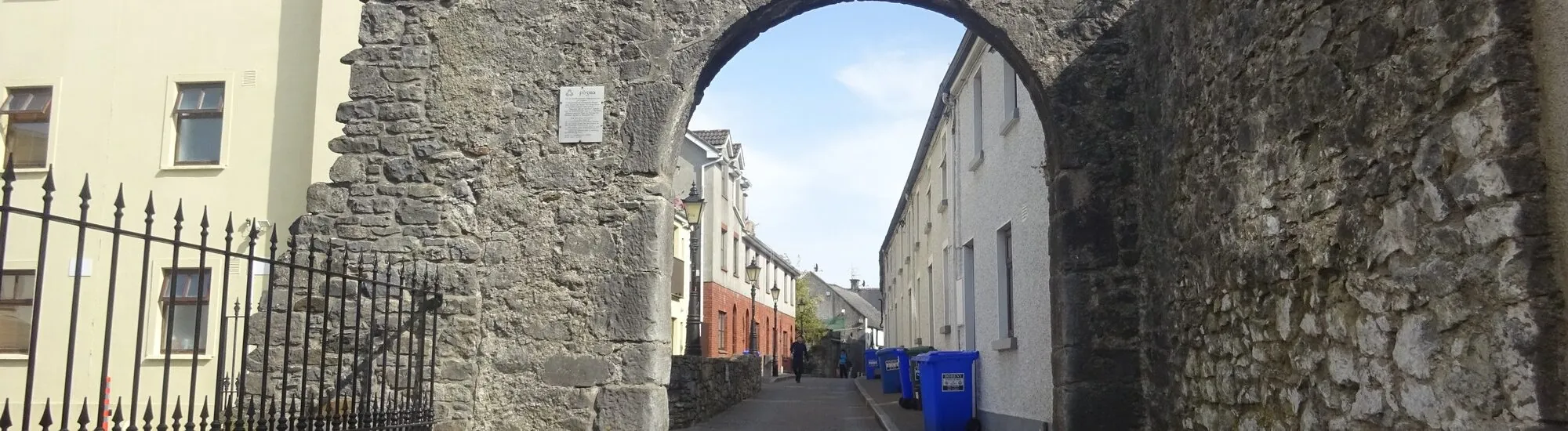
At the end of Abbey Street, a stone arch spans the road. Less conspicuous from a distance than Kilkenny Castle or its church spires, it is nonetheless a valuable landmark for understanding the medieval city. Black Freren Gate is the last surviving gate in the old town walls. It linked Hightown, the fortified district, with the Dominican precinct of the Black Abbey. Today, the passage remains part of the street. To read the monument, pause on the pavement and look at how the arch meets the walls on either side.
The name refers to the Black Friars, the Dominicans, whose convent stood on the edge of the fortified city. The excavation report on the Abbey Street wall identifies the gate as an entrance between Hightown and their precinct. If you are walking down from Parliament Street, use this connection as your guide. The gate marks a boundary in the urban fabric, while the Black Abbey helps explain where it led.
The records brought together in the Kilkenny City Walls Conservation Plan offer several clues to the life of the passage. In 1581, the city leased the gate while reserving the use of the guardhouse for officers responsible for surveillance in times of danger. In 1633, a lease mentions rooms above the entrance and provides for roofing work. These references reveal a building with occupied spaces above the street. The exact form of the former tower remains unknown.
The gate appears on John Rocque’s map of 1758. The conservation plan indicates that it had already been largely demolished by the time of the Ordnance Survey survey of 1841. What remains today, therefore, is an arch and short adjoining sections of wall. To imagine the earlier structure, follow the sides of the opening upwards above the road. The contrast between today’s small arch and the rooms mentioned in the records gives an idea of what has disappeared.
The heritage survey records the arch as approximately 3.6 metres high and 2.4 metres wide. It describes a round-headed arch made of dressed stone blocks. From an unobstructed viewpoint, look at the curve of the opening, then at the contrast between the stones of the arch and the neighbouring masonry. The document also notes a blocked opening nearby. These details help distinguish the main passage from successive alterations, even if the older sections and later repairs remain difficult to date by eye.
The 2007 excavations provide another element for reading the landscape. In a nearby garden, archaeologists observed that the builders had taken advantage of an escarpment at the edge of the former Breagagh floodplain. They place this section of the town wall probably in the 1240s. This estimate concerns the excavated wall. The arch visible today has its own history, illuminated by the later references to the gate and guardhouse. From the street, this difference in chronology explains why the line of the town walls and the date of the visible masonry must be considered separately.
The arch is better understood by looking beyond the road. At this point, the town wall changed direction. Kilkenny Heritage’s presentation locates other remains between New Building Lane, Abbey Street and the Breagagh. Staying on public streets, look for the sections of wall extending around the gate. Houses, gardens and streets have reclaimed part of the space once occupied by the fortification. The walk is therefore about connecting fragments encountered separately.
If you have time to continue, head through the James’s Street area, where another section documented by Kilkenny Heritage survives. Then continue towards Lower New Street and Talbot’s Tower, at the south-west corner of Hightown’s town walls. The two stops illustrate different functions. On Abbey Street, the gate allowed people to pass between the fortified district and the religious precinct. At Talbot’s Tower, the bastion defended a corner of the town wall. The plan of the defences helps connect the two sites along today’s streets.
From Parliament Street, follow Abbey Street westwards. Allow five to ten minutes to look at the arch and adjoining wall. The passage is narrow and lies on the road. To take a photograph, choose a viewpoint from the pavement and avoid stopping in the opening. You can combine the stop with the Black Abbey, then return to the centre via the Medieval Mile Museum. It is a way of moving from the line of the fortifications in the street to the objects and stories preserved in the museum.
Want to extend your visit without having to rush around? Here are a few well-located places to stay near the must-see attractions.
Essential information to help you plan your visit, including key landmarks, access information, and booking options.
Abbey Street, Kilkenny, County Kilkenny, Republic of Ireland, Tourist sites in Ireland
52.65450, -7.25621
Arch visible from the public street, with no visiting hours.
Check the opening hours and admission requirements before you leave, especially during peak season or on Irish public holidays.
Free to view from the public street.