

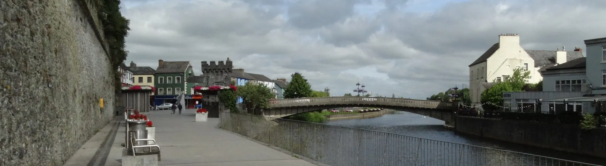
At the foot of Kilkenny Castle, the Nore offers an escape just steps from the shopping streets. From Canal Square, follow a tree-lined path downstream, cross the river via Ossory Footbridge and return along the opposite bank. This is the Canal Walk and Lacken Walk loop, one of the routes in River Nore Linear Park. The outward route passes beneath the castle grounds. On the way back, the city reappears beyond an old mill, a river weir and the terraces of the east bank.
Start at Canal Square, near John’s Bridge, on the west bank. Take the path downstream, with the river on your left and the grounds of Kilkenny Castle on your right. Kilkenny County places Ossory Footbridge around 1.8 km from the start of the Canal Walk. Several passages link the trail with the castle park. If you plan to use one of these entrances, check the gate opening times. The riverside path and access to the grounds operate under different arrangements.
On this bank, the trees occasionally hide the castle and draw your attention back to the river. The county highlights old millraces, mill remains, weirs and traces of the canal. The name Canal Walk may prompt you to look for the canal itself, but the path here follows the Nore. Instead, look at how the water has been channelled or held back in certain places. These structures tell the story of the river’s work, long used to power the town’s mills.
The starting point also has a history tied to the water. An excavation report on Canal Square and its surroundings notes the discovery of an old paved slipway shown on the first Ordnance Survey map. This remnant helps to imagine how the quay was used before it became a riverside walk. As you leave the square, turn back towards John’s Bridge to keep your bearings on the centre before the trail leads away from it.
At Ossory Footbridge, cross the Nore, then head back towards the centre along the east bank. The direction matters. Heading downstream on the other side takes you towards the Nore Valley Walk and Bennettsbridge. For the urban loop, keep heading towards John’s Bridge. The Lacken Walk combines an old path with an elevated boardwalk crossing part of the wet ground. The boardwalk was refurbished in 2024. Near the centre, the route returns towards John Street via the County Hall area.
On the east bank, look out for Lacken Well, a covered spring set into the slope and marked by a plaque dated 1831. Lacken Mill, a former grain mill built in 1774 according to the county, is another landmark. The appeal of the path also lies in the views that open up from time to time. From the Dublin Road viewpoint, you can look out over Lacken Weir, with the castle in the background. This is a separate detour from the riverside route, to choose according to the time you have and the access that suits you.
If you have limited time, walk out and back from Canal Square along the Canal Walk. Decide where to turn around according to the time available, and allow some extra time if you need to make a booked visit. For the two-bank loop, allow around 4 km depending on the access points used, and roughly one hour to one hour and 15 minutes, longer if you stop at the viewpoints. The footbridge is the landmark to aim for on the outward journey; John’s Bridge is the one to find on the way back.
The two banks do not offer the same walking conditions. The Lacken Walk crosses a low-lying, wet area, and access via the Lacken Steps includes stairs. For a walk with a pushchair or wheelchair, check access and route conditions with the parks service before planning the full loop. An out-and-back walk along the west bank lets you choose your own turning point. After heavy rain, follow on-site signage and any restrictions along the river.
River Nore Linear Park extends beyond this loop. Upstream from the centre, the local authority also lists Peace Park on the east bank and the Bishops Meadows Walk. On the west side, the Riverside Garden links the Bateman Quay area with Greens Bridge. These stretches offer further opportunities to encounter the Nore while exploring the city. On your return from the southern loop, you can stop at the Medieval Mile Museum before following the quays northwards.
Want to extend your visit without having to rush around? Here are a few well-located places to stay near the must-see attractions.
Essential information to help you plan your visit, including key landmarks, access information, and booking options.
Canal Square, Kilkenny, County Kilkenny, Republic of Ireland, Tourist sites in Ireland
52.65133, -7.25011
Public outdoor walks. No fixed opening times are confirmed for the entire linear park. Access to the castle park follows its own opening times. Follow signage in the event of restrictions.
Check the opening hours and admission requirements before you leave, especially during peak season or on Irish public holidays.
Free access to the walks in River Nore Linear Park.