

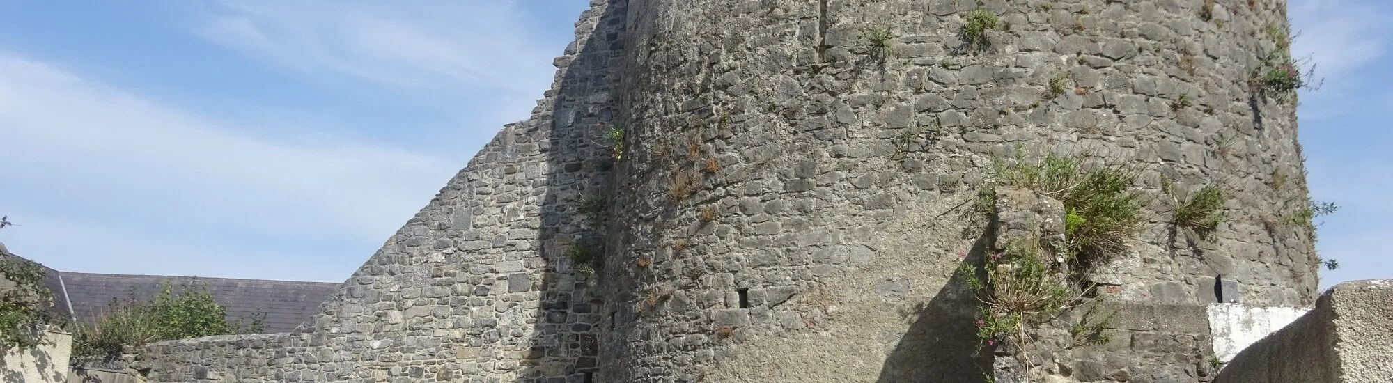
At the corner of Lower New Street and Ormonde Road, a stone tower marks the point where the Kilkenny city wall changed direction. This is Talbot’s Tower, a former bastion of the medieval city, now surrounded by a small public park. Information panels and the masonry make it possible to read the defensive angle from outside. The site also tells a less visible story. Beneath the foundations, archaeologists uncovered evidence of a ditch, an earthen bank and cultivated ground dating back several centuries before the tower was built.
The tower stood at the south-western corner of Hightown’s fortifications, the part of the medieval city associated with the castle and the merchant town. Stone walls began to replace the earlier defences in the 13th century. The conservation plan for the city walls dates the tower’s construction to the late 13th or early 14th century, based on its architecture and the form of its embrasures. Talbot’s Tower is the most complete surviving defensive tower along the line of the city walls.
In the park, begin by looking at the junction between the tower and the wall. The layout becomes clearer when you move a few steps away rather than focusing on the façade alone. The bastion protects a corner. Its projection from the wall allowed defenders to watch the approaches to the fortification. To understand the scale of the system, imagine the city wall continuing beyond what can be seen today, towards the former gates. The streets that now cross this area make the continuity of the enclosure less immediately apparent.
The tower’s name has changed. The conservation plan notes, in particular, the name Wattle’s Bastion in the 19th century, and explains that the attribution of the walls’ construction to Robert Talbot is incorrect. The Kilkenny Heritage brochure on the tower and city walls also traces the period when an ornamental garden occupied its summit. The bastion therefore remained a landmark in the urban landscape long after its military role had ended.
The modern conservation campaign began in 2006. It brought together archaeologists, building specialists and stonemasons. County Kilkenny officially inaugurated the restored site in May 2018. What can be seen today is the result of this work on a monument that had deteriorated over the centuries. The information panels place the walls within the historic landscape and explain why the tower was preserved in the midst of a district that has changed considerably.
Excavations by Kilkenny Archaeology identified a deep ditch overlooked by an earthen bank. Archaeologists believe an oak palisade would have crowned this bank. This first line of defence shows that the stone structures were built in an area that was already fortified. The ditch and bank can be understood through the survey records and information panels. On site, it is above all the later masonry that catches the eye.
The oldest discovery consists of just a few grains. Beneath the bank, an agricultural soil preserved barley grains radiocarbon-dated to the 9th century. The team presents them as the earliest certain evidence of agricultural activity then identified in the Kilkenny area. They date the cultivated ground beneath the fortifications. The stone tower belongs to a much later phase. At a single point in the city, the excavations therefore make it possible to trace the transition from cultivated land to a fortified boundary.
If you compare the park with the historic map reproduced in the heritage brochure, first look for the change in direction of the city wall. It is the easiest detail to identify in the present-day city. Then, by locating the streets that cross the former line, you can follow sections of the enclosure even where the stone has disappeared.
Reach the small park via Lower New Street, near Ormonde Road. Allow around 15 minutes to see the masonry and read the information panels. The park and exterior are the usual visit. The tower interior and roof are available by appointment. If you would like to see them, contact the local county office before planning your visit and ask them to confirm the arrangements. Approaching the park and any ascent of the tower are two different routes. If you have mobility requirements, ask about access to the areas that interest you.
To extend your walk, head back towards Kilkenny Castle and The Parade, or continue to the Medieval Mile Museum. West of the centre, near the Black Abbey, Black Freren Gate provides another reference point on the city walls. Between these stops, the wall is sometimes interrupted or concealed by buildings. Use the fortifications plan as a guide to link the remains with the present-day street layout.
Want to extend your visit without having to rush around? Here are a few well-located places to stay near the must-see attractions.
Essential information to help you plan your visit, including key landmarks, access information, and booking options.
Lower New Street, Kilkenny, County Kilkenny, Republic of Ireland, Tourist sites in Ireland
52.64801, -7.25268
The park is stated to be open daily from 8 am to 8 pm. Interior and roof by appointment; confirm with the Kilkenny Area Office ([email protected]).
Check the opening hours and admission requirements before you leave, especially during peak season or on Irish public holidays.
Free access to the park. For the interior and roof, confirm arrangements when requesting an appointment.