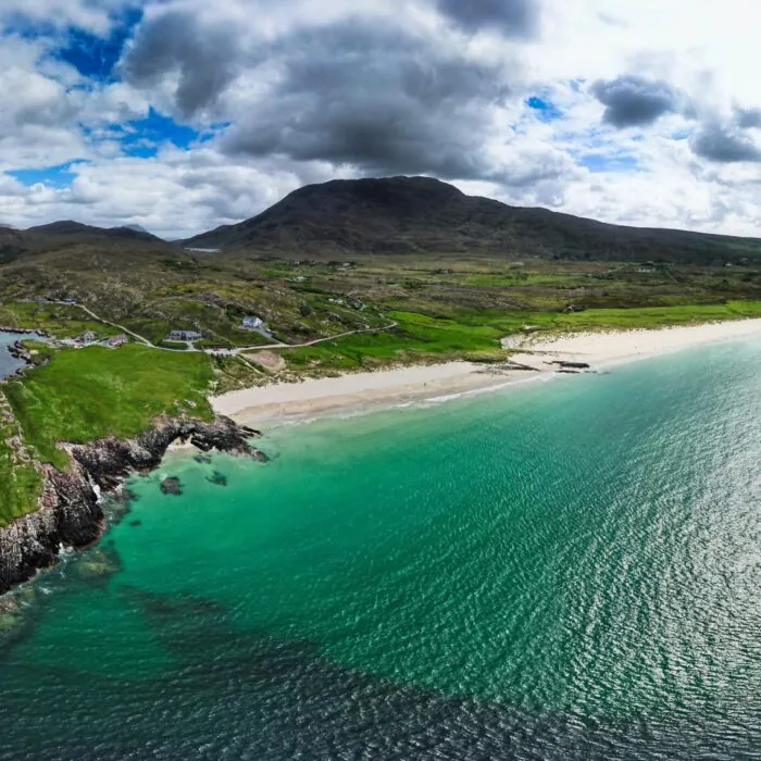


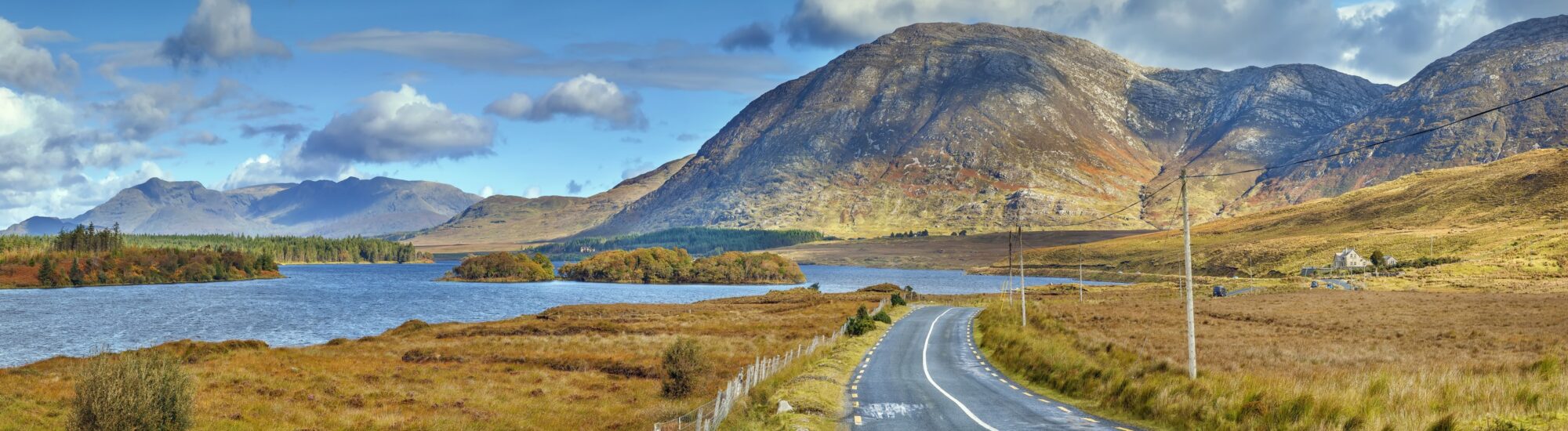
In the heart of Connemara, the Inagh Valley unfolds across an almost mineral landscape. The road winds between the dark outlines of the Twelve Bens and the Maumturk Mountains, alongside still lakes, russet heathland and vast peat bogs. Here, a handful of sheep and isolated houses are enough to remind visitors that, wild as it may seem, this valley remains an inhabited landscape shaped by people.
Also known as Lough Inagh Valley, the Inagh Valley is home to one of County Galway’s finest scenic drives. It is best explored by following the R344 between Recess and northern Connemara. A spectacular detour to include on a route between Galway, Clifden, Kylemore Abbey and Leenane.
The Inagh Valley occupies a long natural corridor separating two of Connemara’s main mountain ranges. To the west rise the Twelve Bens, also known as the Twelve Pins or Na Beanna Beola in Irish. To the east are the Maumturk Mountains, a steeper range whose ridges sometimes seem to disappear into the clouds.
This geography gives the landscape a striking sense of depth. The mountains frame a succession of peat bogs, rivers and lakes fed by the frequent rains of western Ireland. The light changes constantly: a break in the clouds can reveal the purple hues of the heather before a shower returns the summits to their almost black shade.
Bad weather does not necessarily spoil a visit. Rain, mist and low cloud are part of the Inagh Valley’s visual identity. They even enhance its atmosphere, provided you take care on the road and have suitable clothing if you plan to walk.
The R344 runs through the valley for around 25 kilometres between the N59 near Recess and the Kylemore area. This minor road passes Derryclare Lough and Lough Inagh, among other sights, with open views of the Twelve Bens and the Maumturk Mountains.
The road is tarmac, but relatively narrow. It can be wet, lined with ditches and frequented by sheep. Drive slowly, keep your distance and stop only in places wide enough to do so safely. Soft verges and peat bogs do not allow for risk-free parking everywhere.
Without stopping, the drive can be completed in around half an hour. Yet it would be a shame to pass through the Inagh Valley so quickly. Allow at least an hour to watch the landscape change and enjoy the few places where it is safe to stop.
The valley is particularly photogenic in the morning, when clouds still cling to the summits, or later in the day, when low-angled light picks out the contours of the landscape. Conditions change very quickly in Connemara, however: only a few minutes may separate bright skies from a heavy shower.
At the southern end of the valley, Derryclare Lough is one of its most photographed landscapes. The lake lies at the foot of the Twelve Bens and contains a small wooded islet known as Pine Island. Its irregularly shaped pines stand out against the mountains, creating a composition that has become emblematic of Connemara.
A stopping place along the N59 allows visitors to look out over the lake and islet. This area can be busy, and its proximity to the road calls for care. It is best not to walk on the carriageway or park on an unstable verge for a better viewing angle.
Further north, Lough Inagh stretches along the valley floor. Its dark waters reflect the mountain slopes when the wind drops. A former fishing lodge, now converted into a hotel, stands on its shores. It is one of the few buildings visible in this part of Connemara.
Along the R344, small streams cross the peat bogs before joining the lakes. The landscape may appear deserted, yet it supports discreet rural activity. Sheep graze on the slopes, while some plots still bear traces of traditional peat extraction.
The Inagh Valley can be explored on foot, but it should not be regarded as a place where you can walk freely in every direction. Much of the land is privately owned, the peat bogs may conceal unstable ground, and paths can sometimes be difficult to identify.
Walkers should use waymarked routes, respect fences and use designated crossings. A topographical map, waterproof footwear and clothing able to withstand both wind and rain are essential. Mobile phone coverage can be patchy, and the weather changes very quickly in the mountains.
For a first visit, a local guide is an excellent option. They can help you better understand the terrain, the formation of the peat bogs and the valley’s agricultural uses, while reducing the risk of losing your way.
The Western Way crosses part of County Galway between Oughterard and Leenane. This long-distance walking route follows rural roads, forest tracks, peat bogs and several of Connemara’s mountain landscapes.
The section of the Western Way in the Inagh Valley area offers a slower approach to the landscape. It allows walkers to experience the distances, shifting light and isolated character of the valley, far from the quicker discovery offered by the R344.
The route is not technically difficult throughout, but its length, wet ground and weather conditions can make it demanding. Accommodation, shops and services are scarce on some sections, so stages should be planned before setting off.
Located in the Maumturk Mountains, Mám Éan is an ancient pass used for centuries to cross the mountain range. The site is associated with Saint Patrick and remains a place of local pilgrimage, particularly at the beginning of August.
The route leads to a small shrine set in an austere landscape, surrounded by stones, crosses and mountain terrain. There is a chapel, an outdoor altar and various signs of devotion. It is not a summit, but a natural passage rich in history and spirituality.
The path joins a section of the Western Way. The ascent remains accessible to properly equipped walkers, but the ground can become muddy and slippery after rain. In clear weather, the higher ground offers fine views over the surrounding valleys and mountains.
The mountains around Lough Inagh offer several considerably more difficult hikes. The Derryclare Horseshoe, for instance, forms a mountain circuit taking in several summits of the Twelve Bens. The route is around 13 kilometres long, with almost 900 metres of ascent and more than six hours of walking, depending on conditions.
This hike is not suitable for casual walkers. It crosses steep, rocky terrain without continuous waymarking. Navigation becomes difficult when clouds cover the ridges, a frequent occurrence in Connemara. Sound mountain experience, a suitable map and good navigation skills are required.
Less experienced walkers may prefer the accessible sections of the Western Way or the developed trails in Connemara National Park, particularly around Diamond Hill.
The appeal of the Inagh Valley lies less in an accumulation of monuments than in the experience of the landscape. The lakes, mountains and peat bogs change in appearance throughout the day. The surface of Lough Inagh can shift from metallic grey to deep blue, while the slopes range between green, brown and purple.
For photographing the valley, a wide-angle lens will capture its vastness, while a longer focal length helps isolate a summit, a farm or a group of sheep. Rain protection and a cloth for cleaning the lens will often be more useful than heavy equipment.
It is essential to stay in permitted areas and not climb fences to take a photograph. Land around the lakes is often private, fragile or waterlogged. Drones must also be used in accordance with Irish regulations, privacy and the welfare of animals.
Connemara’s peat bogs are particularly fragile natural environments. Their soil, formed by the very slow accumulation of plant matter, can be permanently damaged by the repeated passage of vehicles and walkers.
Do not leave established roads and paths, never park your vehicle on peatland, and take all your rubbish away with you. Sheep may roam freely near the road: slow down without frightening them, and keep dogs under control.
The Inagh Valley is not an empty backdrop. Fences, farm tracks and grazing areas belong to local farms. Respecting private property and closing gates when an authorised route requires you to pass through them directly helps preserve access to walking paths.
In this valley, the best experience is often the simplest: slow down, listen to the wind moving through the grasses and watch clouds drift across the Twelve Bens. The Inagh Valley then reveals what is most striking about Connemara: a rugged, silent landscape that is always changing.
Want to extend your visit without having to rush around? Here are a few well-located places to stay near the must-see attractions.
Essential information to help you plan your visit, including key landmarks, access information, and booking options.
Prendre la R344 puis la N59, Connemara National Park, Connemara National Park
53.520602, -9.741667