The Lough Googh Loop Walk is one of the most challenging walks in County Kerry. It’s definitely for more experienced hikers! Magnificent and attractive, it will allow you to discover part of Killarney National Park, which is in itself one of Ireland’s most popular attractions!
The Lough Googh Loop Walk is a hiking trail that forms a loop in the middle of Killarney National Park. The tour is not to be taken lightly: it will take you over ridgelines and across some of County Kerry’s most impressive mountains: the Big Gun (939 meters. One of the peaks at the eastern end of the Macgillycuddy’s Reeks range), Cnoc na Péiste (988 meters), and Cruach Mhór (932 meters).
These ridges are much more difficult and narrow than the popular Beenkeragh ridge, which stretches all the way to Carrauntoohil.
This hike takes 6-7 hours with around 900 meters of ascent and plenty of steep, narrow terrain to negotiate. This is a serious 10km route, with some climbing – you’ll need good balance on the rock and a good sense of altitude. What’s more, vertigo sufferers will clearly have no place here, as some of the passages can make them break out in a cold sweat.
A few parking spaces are available at the southern (Black Valley) end of the Gap of Dunloe, at Head of the Gap.
You’ll start the loop in the direction of Lough Googh or Loch gCuach, which means “cuckoo lake”. It’s literally a pretty lake in the national park, famous for being home to cuckoos, a species of bird accustomed to the area!
Follow the path along the river and its many waterfalls to Lough Googh. Once you’ve arrived, take time to admire the view: the lake is sublime, full of charm and mystery!
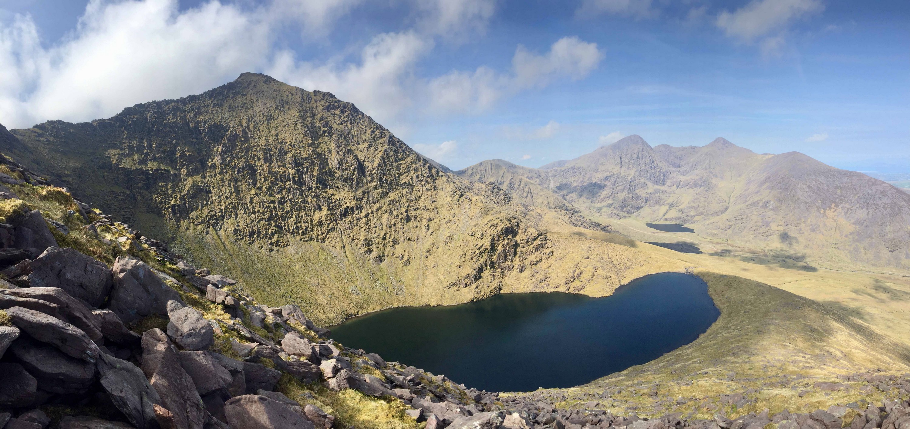
Once at the top of Feabrahy, turn right and climb steeply until you reach the summit of Cnoc na Péiste ((Ireland’s fourth highest peak, called “Snake Hill”) marked by a pile of rocks. The view that stretches along its narrow ridge to the next peaks – Big Gun and Cruach Mhór – is one of Ireland’s most beautiful and frightening mountain vistas.
Below, in a dark corrie to the north, lies Lough Cummeenapeasta (“Lake of the Serpent’s Coum”), protected by sheer cliffs. It was here, early on December 17, 1943, that a DC3 transport plane flying from Morocco to England went off course and crashed into the cliffs. Conditions were wild at the time and no one saw or reported the incident – it was only discovered a month and a half later.
Cnoc na Péiste is linked to the Big Gun by a sharp ridge. A well-defined path sometimes passes along the north side of the ridge at its opposite end, but the safest option is to take a rocky path further down on the south side of Lough Googh, which will save you any difficulties you might encounter climbing up the ridge.
At the end of the ridge, you’ll need to turn north and climb a steep, rocky section, then carefully climb up to reach a small cairn that adorns the exposed, table-sized summit of the Big Gun. There are magnificent views of Cruach Mhór, Lough Cummeenapeasta, Cnoc na Péiste and Carrauntoohil, Ireland’s highest peak.
The ridge becomes narrow again, with large boulders forming slabs and pointed pinnacles, or gendarmes. Experienced climbers with a fear of heights may want to cross this ridge. However, most hikers are advised to tackle the ridge by skirting all the pinnacles and rock slabs from the left or right (whichever is easier) using the vestigial paths. However, even then, some climbing may be necessary, and you’ll need to put your hands on the rock. Take care not to lose too much height when going around these rocky features.
All difficulties cease when you reach a wide section of the ridge below Cruach Mhór.
Climb up the slope to a large stone grotto at the top. A local man, Tommy Sullivan, worked for years to bring cement, gravel and water to these heights to build this cave in the 1970s.
From here on in, all the difficulties pale in comparison to what you’ve been through.
Descend northeast to Cruach Bheag, then descend to a saddle before continuing to Cnoc an Bhráca and Cnoc na Tarbh before turning south down a spur to Drishana.
Leave the spur some 275 m after Cnoc na Tarbh, turning left and descending steeply to the southeast to Gap Cottage. Once on the road, turn right and return to your car at Head of the Gap.
This loop is designed for hardy walkers with hiking experience and a good knowledge of climbing. We also recommend that you have good map and compass skills. This is essential if you are to make progress without getting lost and follow the loop.
And don’t forget to bring the right equipment. Wear good hiking pants (no jeans) and, even in summer, bring a hat and warm gloves. Make sure you also pack an extra layer of fleece and waterproof clothing, in case it rains. You’ll need good shoes for this hike, ideally 3-4 season shoes with good ankle support. Bring a headlamp, packed lunch and plenty of fluids. Take a charged cell phone with you, and if you need to call mountain rescue, dial 999 or 112. Note also that in rainy weather, rivers can be difficult to cross.
And don’t hesitate to check the weather forecast before you set off on your adventure! Macgillycuddy’s Reeks have their own microclimate, resulting in low clouds and/or mist.
Don’t forget that most accidents happen on the way down, and in poor visibility it’s imperative to take the correct descent route.
 Address:
 GPS :
GPS :


 4.42/5 (1,079 votes)


 3.51/5 (90 votes)